FOUNDATION WORKSHOP · GIS
GeoServer 3 on Kubernetes
a simple, durable geospatial platform
Live demo meteo-gis.sladoire.dev/geoserver/web
Full documentation meteo-gis-docs.sladoire.dev
Everything shown here is running and tested — not a paper design.
The big picture — identical replicas, shared data
No local state. Every replica reads the same database and the same object store — kill any of them, nothing is lost.
Nobody configures anything by hand
All configuration is code. A new layer is one declarative line:
# platform configuration (ConfigMap)
MOSAICS: "… ; goes19_abi_ir103 | goes19_abi_ir103 | sat | brightness_temperature | GOES-19 ABI IR 10.3 µm"
MOSAICS: "… ; goes19_abi_ir103 | goes19_abi_ir103 | sat | brightness_temperature | GOES-19 ABI IR 10.3 µm"
▼ at startup, every replica applies it ▼
meteo-gis init: mosaic published: meteo:goes19_abi_ir103 (K)
meteo-gis init: tile layer created: meteo:goes19_abi_ir103 (gridsets 2)
meteo-gis init: tile layer created: meteo:goes19_abi_ir103 (gridsets 2)
Consequence: any environment can be rebuilt identically from code — no snowflake server, no “only Bob knows how it's set up”.
Replicas are disposable — and we measured it
- Config change visible on all replicas in ~3 seconds — 2 s of it is a deliberate, tunable debounce; delivery itself is milliseconds, and new data needs no propagation at all
- Scaling 3 → 5 → 3 replicas under load: 0 request errors
- User sessions survive the loss of a replica (shared in the cluster)
Durability: upgrades and failures become routine — replace instances, never repair them.
What is in the object store
Real content of the demo store — file names carry satellite/sensor or model/parameter and the exact time (naming convention):
buckets/
├── rasters/                                    each image stored once, as COG
│   ├── models/arpege/t/
│   │   └── arpege_t_isobaric85000_20260901T00Z_20260901T06Z.tif   run · validity
│   └── sat/
│       ├── meteosat-12/fci/meteosat-12_fci_ir105_20260901T1200Z.tif
│       └── goes-19/abi/goes-19_abi_ir103_20260904T1400Z.tif      real GOES-19 data
└── gwc-tiles/                                  rendered map tiles — shared cache,
    └── meteo_goes19_abi_ir103/…                a tile rendered once serves everyone
COG = Cloud-Optimized GeoTIFF: replicas read only the byte ranges they need, straight from S3 — no copies on local disks.
Finding the right image — satellite index
One S3 file = one row. GeoServer answers “this area, this instant” with one indexed query. (table sat_granule, real rows)
| fid PK | satellite UQ IDX | instrument UQ IDX | product UQ IDX | time UQ IDX | param_key FK | location |
|---|---|---|---|---|---|---|
| 7 | goes-19 | abi | ir103 | 2026-09-04 13:00Z | brightness_temperature | …_ir103_1300Z.tif |
| 8 | goes-19 | abi | ir103 | 2026-09-04 14:00Z | brightness_temperature | …_ir103_1400Z.tif |
| 2 | meteosat-12 | fci | ir105 | 2026-09-01 12:10Z | brightness_temperature | …_ir105_1210Z.tif |
PK primary key ·
UQ UNIQUE (satellite, instrument, product, time) — same instant ingested twice = update, never a duplicate ·
IDX lookup index — the time navigation query
param_key points to the shared parameter referential: every quantity has a canonical unit (here kelvin). A measurement always has a unit.
Finding the right image — model index
Models add two dimensions: the run (reference_time) and the level. Same pattern, richer key. (table model_granule)
| fid PK | model UQ IDX | param_key UQ IDX | reference_time UQ | time UQ IDX | elevation UQ | level_type |
|---|---|---|---|---|---|---|
| 1 | arpege | air_temperature | 2026-09-01 00Z run | 2026-09-01 00Z | 85000 | isobaric (Pa) |
| 2 | arpege | air_temperature | 2026-09-01 00Z | 2026-09-01 06Z +6 h | 85000 | isobaric (Pa) |
| 5 | arpege | air_temperature | 2026-09-01 00Z | 2026-09-01 06Z | 50000 500 hPa | isobaric (Pa) |
UQ UNIQUE (model, param_key, reference_time, time, elevation) ·
IDX lookup (model, param_key, time) ·
GIST spatial index on the raster footprint (
the_geom, not shown) ·
each row also carries location — the s3:// path of the granule file (shown on the satellite slide, omitted here for width)
Clients navigate time, altitude and forecast run — each step is one indexed query on this table, served through standard WMS dimensions.
Observations — SYNOP, METAR, …
The station (written once)
| station_id PK | name | geom | elevation |
|---|---|---|---|
| LFPG | Paris-CDG | point (4326) | 119 |
| ESSA | Stockholm-Arlanda | point (4326) | 42 |
The measurements (time-partitioned — TimescaleDB hypertable)
| station_id PK | time PK IDX | param_key PK IDX | value | source_unit | message_type |
|---|---|---|---|---|---|
| LFPG | 2026-09-04 14:00Z | air_temperature | 293.4 K | Cel | METAR |
| LFPG | 2026-09-04 15:00Z | air_temperature | 292.8 | Cel | SYNOP |
| ESSA | 2026-09-04 14:00Z | air_temperature | 286.1 | Cel | METAR |
PK (station_id, time, param_key) — natural key, duplicates impossible ·
IDX (param_key, time DESC) — “latest value everywhere” query
Values are stored in the canonical unit (kelvin), the source unit is kept. Decoded °C and model K can never be mixed up. GeoServer publishes SQL views on top — decoders and GIS stay decoupled.
Navigating time and altitude is standard
No custom API. Clients add standard WMS dimensions to the map request:
…/geoserver/ows?request=GetMap&layers=meteo:arpege_t
&TIME=2026-09-01T06:00Z ← validity instant
&ELEVATION=50000 ← level (here 500 hPa)
&DIM_REFERENCE_TIME=2026-09-01T00:00Z ← forecast run
&TIME=2026-09-01T06:00Z ← validity instant
&ELEVATION=50000 ← level (here 500 hPa)
&DIM_REFERENCE_TIME=2026-09-01T00:00Z ← forecast run
- The server advertises available times/levels — clients build sliders from it
- Works in our future UI, QGIS, or any OGC tool, today
- Palettes are applied server-side at request time (styles) — same data, many looks
Standards over custom code: less to build, less to maintain, nothing proprietary to explain to integrators.
Real data, live on the demo
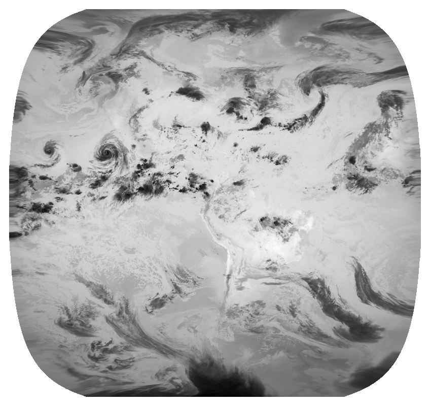
- GOES-19 — infrared 10.3 µm,
brightness temperature (K) - Public NOAA source — anyone can rerun the ingestion
- 6 hourly images, navigable in time
- Added with 1 ingestion job + 1 config line
This image is served by the platform you are looking at — meteo-gis.sladoire.dev. Two live tropical cyclones on the left.
Where this stands — and what we decide together
Proven, rerunnable tests
- Database bootstrap, image build, 3-replica cluster
- S3 tiles + COG rasters, model/sat/obs ingestion
- Server-side interpolation (IDW + comparative study)
- Whole stack redeployed from the written runbooks
on a second cluster, zero deviation
Deliberately open — workshop decisions
- Identity / RBAC integration
- Common UI framework
- Observability stack
- Messaging (if the platform adopts one)
- Data retention: owner & policy
Details, decision records and runbooks: meteo-gis-docs.sladoire.dev — every claim in this deck links to its proof there.