ImageMosaic ingestion — time series and multi-dimensional models
Goal: continuously publish weather rasters (models: model run × forecast validity time × vertical level; satellites: time series) as GeoServer ImageMosaic layers, COGs on S3 indexed in PostGIS, visible to all replicas as soon as they are ingested, with the quantity's unit known and displayed.
flowchart LR
    SRC[Sources<br/>models, satellites] --> ING[Ingestion service<br/>Python + GDAL]
    ING -- "COG (canonical unit)" --> S3[(rasters bucket)]
    ING -- "INSERT index + one view per mosaic" --> DB[(mosaic schema<br/>parameter · model_granule · sat_granule)]
    GS[GeoServer ×N] -- "jdbc/meteo (read)" --> DB
    GS -- "range reads" --> S3
    PLUG[geoserver-init plugin<br/>MOSAICS ConfigMap] -- "indexer/datastore.properties (Resource API)<br/>coverage + dimensions + title (unit)" --> GS
C[WMS clients] -- "TIME · ELEVATION · DIM_REFERENCE_TIME" --> GSDecisions: ADR-0003
(accepted), ADR-0010.
Artifacts: poc/05-ingestion/ (schema, service, Jobs, tests).
Prerequisites
Sub-projects 1 to 4 (database, image, cluster, S3). Secrets: ingestion-db
(ingestion service account), s3-credentials, meteo-reader.
Data model (mosaic schema, owned by the ingestion service)
| Table | Role |
|---|---|
parameter |
One physical quantity = one row: param_key, cf_standard_name, canonical_unit, label |
parameter_code |
Known codes per scheme (grib2, eccodes, bufr, metar, cf) with the unit in that scheme |
level_type |
Level types (GRIB2 table 4.5) |
model_granule |
One row per model COG: the_geom, location (s3://…), model, param_key, reference_time (model run), time (validity), elevation, level_type, level_label, source_unit, ingested_at |
sat_granule |
One row per satellite image: satellite, instrument, product, param_key, time, source_unit |
views arpege_t, meteosat12_fci_ir105… |
One view per mosaic (filter on model+quantity or satellite+instrument+product); gt_pk_metadata declares fid as the key for GeoTools |
The schema is created by a Job (admin account), GeoServer's reader receives
SELECT through grant-reader (sub-project 1); datastore.properties
specifies schema=mosaic.
Ingestion service
ghcr.io/osgeo/gdal container + Python (boto3, psycopg, numpy),
CLI ingest.py model | sat. For each granule:
- field (synthetic at the prototype stage — actual GRIB/NetCDF decoding is out of scope);
- conversion to the canonical unit of the reference table (demonstrated:
source
Cel→K),source_unitpreserved; - writing of a COG (GDAL, DEFLATE, 256 tiles) with metadata
param_key,units,time,reference_time, level; - S3
put_objectfollowing the ADR-0003 convention (models/arpege/t/arpege_t_isobaric85000_20260901T00Z_20260901T06Z.tif,sat/meteosat-12/fci/meteosat-12_fci_ir105_20260901T1200Z.tif); INSERT … ON CONFLICT DO UPDATEinto the index andCREATE OR REPLACE VIEWof the mosaic.
Run as a Job (k8s/job-ingest-demo.yaml, ingest.sh); CronJob or
orchestrator in production. A quantity absent from the reference table =
explicit error ("add it to mosaic.parameter").
Real-data example: GOES-19 from NOAA Open Data
fetch_goes.py (+ k8s/job-ingest-goes.yaml) ingests real satellite
imagery through the exact same conventions: GOES-19 ABI channel 13
(infrared 10.3 µm brightness temperature, kelvin) from the public NOAA
bucket https://noaa-goes19.s3.amazonaws.com — anonymous HTTPS, one
full-disk granule every 10 minutes, reproducible by anyone. Each granule is
converted from the geostationary NetCDF to an EPSG:4326 COG (GDAL Warp),
uploaded as sat/goes-19/abi/goes-19_abi_ir103_<time>.tif and indexed with
its real acquisition time and footprint. Publication is then the usual
one-line MOSAICS entry (goes19_abi_ir103|…) — run the ingestion Job
before declaring the mosaic. Two pitfalls: the ubuntu-small GDAL image
has no netCDF driver (the ingestion image uses ubuntu-full), and the
"Unhandled X/Y axis unit rad" warning is harmless (the warped bounds are
correct).
Publication by the plugin (declarative)
geoserver-mosaics ConfigMap: MOSAICS="name|view|kind|param_key|title;…".
For each entry, at each pod's startup:
mosaics/<name>/indexer.properties(Cog=true,CogRangeReader=…S3RangeReader,UseExistingSchema=true,CanBeEmpty=true,TypeName=<view>,TimeAttribute=time,ElevationAttribute=elevation,AdditionalDomainAttributes=reference_timefor models) anddatastore.properties(PostgisNGJNDIDataStoreFactory,jndiReferenceName=java:comp/env/jdbc/meteo,schema=mosaic) — written through theResourceAPI, hence stored in the database by JDBCStore and shared;ImageMosaicstore (file:mosaics/<name>), coverage and layer;- dimensions enabled:
time(LIST, default MAXIMUM),elevation(Pa), custom dimensionreference_time; - title = label + canonical unit read from
mosaic.parameterthrough the JNDI resource, abstract and keywordsunit:K,param:air_temperature.
The S3 credentials of the RangeReader come from the environment
(IIO_S3_AWS_*, sub-project 4): no secret in the mosaic files.
No notification needed
ImageMosaic queries the database index on every request, dimension
domains included: a granule inserted by the ingestion is visible in the
GetCapabilities and served by all pods immediately, without any
restart or message (test 03). File-based mosaics would have required a
per-node harvest — that is the reason behind the "index in the
database" choice.
Verification (tests in poc/05-ingestion/tests/)
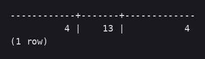
Schema and reference table, demonstration ingestion (6 model granules, 3 satellite ones):

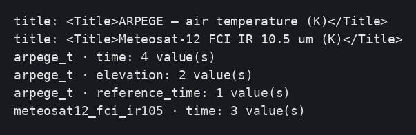
01 Capabilities: titles carrying the unit, dimensions and their values:
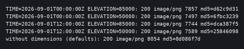
02 GetMap by TIME × ELEVATION: different images (md5), defaults when no
dimension is given:

03 New forecast validity time ingested → 4 time values on both pods,
GetMap served, pods unchanged:

04 Satellite mosaic per instant:


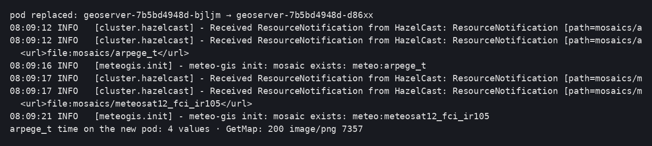
05 Pod replaced: mosaics still published:
Deviations and pitfalls observed
- The reader role now serves several schemas:
grant-reader.sqlno longer redefines an existingsearch_path; the stores specifyschema=. - Views as the index: virtual key
fiddeclared ingt_pk_metadata. - The mosaic configuration files go through the
ResourceAPI (JDBCStore): shared between pods, regenerated at every startup.